ㅁ Add-on 가능: 고객의 요청에 따라 일정한 범위 내에서 Customization이 가능합니다. 자세한 사항은 문의해 주시기 바랍니다.
ㅁ 보고서에 따라 최신 정보로 업데이트하여 보내드립니다. 배송기일은 문의해 주시기 바랍니다.
한글목차
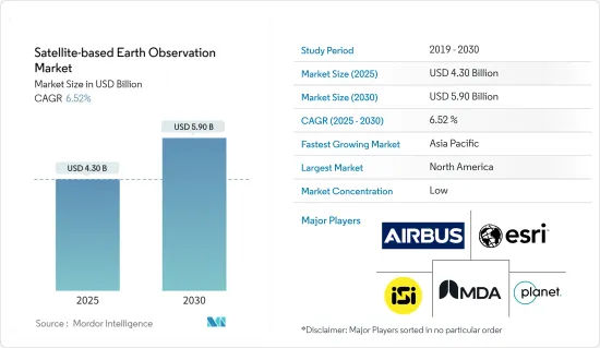
위성 기반 지구관측 시장 규모는 2025년에 43억 달러로 추정되고, 2030년에는 59억 달러에 달할 것으로 예측되며, 예측 기간 중(2025-2030년) CAGR은 6.52%를 나타낼 전망입니다.
위성 기반 지구 관측은 원격 탐사를 통해 지구의 다양한 문제와 관련된 정보를 수집하는 과정입니다. 이는 인간의 삶과 환경에 영향을 미치는 다양한 분야에 사용됩니다. 우주 기술은 개발 과제를 해결하는 데 도움이 되는 중요한 정보를 제공합니다. 지구 관측 위성은 우주에서 데이터를 수집하여 지구의 자연 및 인공 환경, 시간이 지남에 따라 지역이 어떻게 변화하는지, 정책 결정자들이 이러한 변화를 완화하기 위해 무엇을 할 수 있는지에 대한 귀중한 통찰력을 제공합니다. 이 데이터는 개발, 원조, 구호 활동을 하는 기관과 단체에서 활용되고 있습니다.
주요 하이라이트
유럽연합 집행위원회는 최근 전 세계적인 삼림 벌채 문제를 해결하기 위한 법안을 도입했습니다. 이에 따라 삼림 벌채 관련 상품을 판매하는 사업자는 이제 의무적으로 실사를 수행해야 합니다. 기업은 제품이 생산되는 토지에 대한 지리 정보를 확보하여 삼림 파괴가 없는 상품만 EU 시장에서 판매할 수 있도록 해야 합니다. 이러한 발전은 공급망 추적을 위한 위성 데이터에 대한 수요 증가로 이어져 시장 성장에 기여하고 있습니다.
광활한 국토를 효율적으로 모니터링하려는 수요의 증가는 실제로 위성 기반 지구 관측 시장의 성장을 견인하고 있습니다.
스마트 시티 전략이 위성 기반 지구 관측 기술에 대한 수요를 주도하고 있습니다. 이는 도시 계획, 인프라 관리, 환경 모니터링, 재난 대응 등 다양한 목적으로 위성 데이터를 활용합니다. 스마트 시티가 효율성과 지속 가능성을 위해 노력함에 따라 위성 기반 지구 관측은 정보에 입각한 의사 결정과 효과적인 자원 배분을 위한 실시간 데이터와 인사이트를 제공합니다.
오픈 소스 데이터는 무료로 제공되는 경우가 많기 때문에 독점 위성 데이터를 구매하는 것에 비해 기업과 연구자의 진입 장벽이 낮습니다.
경기 침체기에는 정부가 예산을 긴축하여 재량 지출을 삭감하는 경우가 많습니다. 이는 지구 관측 데이터의 주요 수요처인 우주 프로그램과 환경 모니터링 노력에 대한 투자에 영향을 미칠 수 있습니다. 경기 침체는 경제적 불확실성을 야기하여 기업들이 투자에 더욱 신중을 기하게 만듭니다. 따라서 기업들은 특히 당장의 재정적 문제를 직접적으로 해결해야 하는 경우 위성 이미지 및 관련 서비스에 대한 지출을 연기하거나 줄일 수 있습니다.
위성 기반 지구관측 시장 동향
가장 빠르게 성장하는 도시 개발 용도
도시 개발 분야의 새로운 스타트업을 지원하려는 정부의 노력이 시장 성장을 견인할 것으로 보입니다. 예를 들어, 2023년 12월 인도 우주부 산하 노드 기관은 국립 원격 감지 센터와 협력하여 우주 기술을 활용한 도시 개발 및 재난 관리 분야의 스타트업을 지원하기 위한 시드 펀드 제도를 시작했습니다.
이 스타트업은 재정 지원을 받아 도시 계획 및 개발을 위한 EO 데이터를 개발할 예정입니다. 이는 도시 개발의 중요한 과제를 해결하는 새로운 서비스 창출로 이어질 수 있습니다. 또한, EO 기반 솔루션을 보유한 스타트업의 수가 증가함에 따라 제공되는 서비스의 범위가 넓어질 것으로 예상됩니다.
도시 인구의 급속한 증가로 인해 도시 개발에 대한 투자가 증가하면서 시장 성장을 지원하는 인프라 시설에 대한 필요성이 커지고 있습니다. 인구 통계국에 따르면 2023년 전 세계 도시화율은 57%에 달할 것으로 예상됩니다. 북미, 라틴 아메리카, 카리브해 지역은 인구의 5분의 4 이상이 도시 지역에 거주하며 도시화 수준이 가장 높은 지역입니다.
2022년 미국 주택 도시 개발부는 약 293억 1,000만 달러를 지출할 것이라고 보고했습니다. 미국 행정관리예산국의 예측에서 이 숫자는 2028년까지 약 802억 6,000만 달러로 증가할 것으로 예상됩니다.
최근 고해상도 위성 이미지 제공업체인 Satellogic은 GeoterraImage와 협력하여 남아프리카 시장에 완전 자동화된 건물 개발 감지 및 모니터링 시스템을 도입했습니다. 이 시스템은 남아공의 지방 자치 단체와 지방 정부를 위해 새로운 개발을 모니터링하고 매핑하는 효율적이고 비용 효과적인 솔루션을 제공합니다.
북미가 큰 시장 점유율을 차지
북미는 고해상도 데이터를 찾는 농업, 환경, 국방 등의 분야에 힘입어 위성 기반 지구 관측에 대한 수요가 급증하고 있습니다. 위성 이미지는 북미의 광활하고 외딴 지역의 환경 문제를 모니터링하는 데 중요한 역할을 합니다. 예를 들어, 미국 해양대기청(NOAA)의 위성은 매주 오존 농도를 분석하고 빙산의 움직임을 추적하며 산불이나 뇌우와 같은 이벤트에 대한 데이터를 제공합니다. 이러한 정보는 지속 가능한 자원 관리를 위한 데이터 기반 정책을 수립하는 데 도움이 됩니다.
국방군이 반란 전술과 가상 전쟁 등 진화하는 위협에 직면함에 따라 정보 수집은 지상 작전만큼이나 중요해지고 있습니다.
북미 지역은 국방 부문에 대한 투자가 증가하면서 시장 플레이어에게 기회를 제공하고 있습니다. 또한 2023년 11월, 인도와 미국은 2024년 초에 공동 마이크로파 원격 감지 위성인 NASA-ISRO 합성개구레이더(NISAR)를 발사할 계획이라고 발표했습니다.
도시 개발은 북미에서 위성 이미지에 대한 수요를 주도하는 주요 응용 분야입니다. 고해상도 위성 이미지를 통해 도로망, 인프라, 토지 피복 변화 등 도시 지역에 대한 상세한 평가가 가능합니다.
예를 들어, 2024년 3월, Vexcel Data Program은 미국에서의 연간 항공 이미지 수집을 확대해, 하위 48주의 440만 km사방을 커버하게 되었습니다.
위성 이미지 시장은 여러 분야에서 그 중요성이 커지고 특히 환경 및 국방과 같은 분야에서 정부의 투자가 증가함에 따라 눈에 띄는 상승세를 보이고 있습니다.
위성 기반 지구관측 산업 개요
위성 기반 지구 관측 시장은 글로벌 기업과 중소기업이 혼합되어 상당히 세분화되어 있으며, 주요 업체로는 Airbus Defence and Space(Airbus SE), Esri Inc, Imagesat International(ISI) Ltd, MDA Corporation(Maxar Technologies), Planet Labs PBC 등이 있습니다. 시장 참여자들은 제품 라인을 개선하고 지속적인 경쟁 우위를 확보하기 위해 파트너십 및 인수와 같은 전략을 채택하고 있습니다.
2024년 3월 : Ursa Space Systems Inc.는 영국의 국방 정보 분야 전문 중소기업인 MAIAR와 제휴하여 영국의 작전 사용자에게 혜택을 제공하는 데 중점을 두고 NATO의 지리공간 및 오픈소스 분석을 강화했습니다. 이 협력은 임무의 복잡성에 대한 MAIAR의 깊은 이해와 Ursa의 고급 분석 플랫폼을 활용하여 지리공간 분석에 대한 신속하고 영향력 있는 접근 방식을 제공합니다. 두 회사는 협력하여 배송 시간을 단축하고 결과의 규모를 극대화하여 영국과 NATO 고객 모두에게 향상된 가치를 보장할 준비가 되어 있습니다.
2024년 1월 : 이미지사트인터내셔널(ISI)은 5년 동안 미공개 전략 고객에게 위성 서비스를 제공하는 총액 약 3,750만 달러 규모의 계약을 체결했다고 발표했습니다. 이 계약에 따라 ISI는 EROS C2 및 EROS C3 위성과 유지보수 및 지상국 서비스를 통해 고객에게 30cm 해상도의 이미징 서비스를 제공하게 됩니다.
기타 혜택
엑셀 형식 시장 예측(ME) 시트
3개월간의 애널리스트 지원
목차
제1장 서론
조사의 전제조건과 시장 정의
조사 범위
제2장 조사 방법
제3장 주요 요약
제4장 시장 인사이트
시장 개요
업계의 매력도 - Porter's Five Forces 분석
공급기업의 협상력
구매자 및 소비자의 협상력
신규 참가업체의 위협
대체품의 위협
경쟁 기업간 경쟁 관계
거시경제 시나리오 분석(경기 후퇴, 러시아-우크라이나 전쟁 위기 등)
제5장 시장 역학
시장 성장 촉진요인
광활한 토지 지역의 효율적인 모니터링에 대한 요구 사항 증가
스마트 시티 노력의 고조
빅데이터 및 이미지 분석
시장 성장 억제요인
다양한 국가에서 오픈 소스 데이터의 가용성
지구관측의 주된 이용 사례의 분석
교통 인프라 인텔리전스
재난 위험 평가
강 유역 홍수 관리
도시 환경 및 기후 변화 적응
수력 발전 개발
가격 및 가격 책정 모델 분석
생태계 분석
지리 공간 이미지 분석 및 관련 성장 추세 개요
제6장 시장 세분화
서비스별
데이터
부가가치 서비스
기술별
합성개구레이더(SAR)
광학
용도별
도시 개발
농업
기후 및 환경
에너지
인프라 모니터링
재난 및 비상 관리
기타
지역별
북미
유럽
아시아태평양
중동 및 아프리카
라틴아메리카
제7장 경쟁 구도
기업 프로파일
Airbus Defence and Space(Airbus SE)
ESRI INC.
IMAGESAT International(ISI) LTD
MDA Corporation(Maxar Technologies)
PLANET LABS PBC
PlanetIQ LLC
EOS Data Analytics Inc.
L3harris Technologies Inc.
ICEYE
BLACKSKY TECHNOLOGY INC.
Capella Space
Ursa Space Systems Inc.
Descartes Lab
Orbital Insight
Spacceknow Inc.
제8장 투자 분석
HBR
영문 목차
영문목차
The Satellite-based Earth Observation Market size is estimated at USD 4.30 billion in 2025, and is expected to reach USD 5.90 billion by 2030, at a CAGR of 6.52% during the forecast period (2025-2030).
Satellite-based earth observation is a process of collecting information related to the Earth's various issues using remote sensing. It is used in various applications that impact human life and the environment. Space technology offers vital information that helps address development challenges. Earth observation satellites have been collecting data from space, providing valuable insights into the Earth's natural and artificial environment, how its regions change over time, and what policy-makers can do to mitigate these changes. This data is used by agencies and institutions working in development, aid, and relief.
Key Highlights
The European Commission has recently introduced legislation aimed at tackling global deforestation. As a result, operators who sell deforestation-related commodities are now required to conduct mandatory due diligence. Companies must obtain geographical information about the land where their products are produced to ensure that only deforestation-free goods are sold in the EU market. This development has led to increased demand for satellite data for supply chain tracking, contributing to the market's growth.
The increasing demand for efficient monitoring of vast land areas is indeed driving the growth of the satellite-based Earth observation market. This surge is attributable to the need to manage and observe natural resources, urban development, agricultural activities, environmental changes, and security concerns on a global scale.
Smart city initiatives are driving the demand for satellite-based Earth observation technology. These initiatives utilize satellite data for various purposes like urban planning, infrastructure management, environmental monitoring, and disaster response. As smart cities strive for efficiency and sustainability, satellite-based Earth observation provides real-time data and insights for informed decision-making and effective resource allocation. Consequently, the increasing adoption of smart city initiatives worldwide is fueling the growth of the satellite-based Earth observation market.
Open-source data is often freely available, reducing the barrier to entry for businesses and researchers compared to purchasing proprietary satellite data. The open-source data is more accessible to a wider range of users, enabling greater innovation and development of applications in areas such as agriculture, urban planning, and environmental monitoring.
During recessions, governments often tighten their budgets, leading to cuts in discretionary spending. This may impact investments in space programs and environmental monitoring initiatives, which are major consumers of Earth observation data. Recession creates economic uncertainty, causing businesses to become more cautious with their investments. Thus, companies might postpone or reduce their spending on satellite imagery and related services, especially when the perceived value proposition needs to address immediate financial concerns directly.
Satellite-based Earth Observation Market Trends
Urban Development to be the Fastest Growing Application
The government initiatives to support new startups in urban development are likely to drive market growth. For instance, in December 2023, the Indian nodal agency in the Department of Space, in collaboration with the National Remote Sensing Center, launched a seed fund scheme to support startups operating in urban development and disaster management using space technology.
With financial assistance, the startups are expected to develop applications of EO data for urban planning and development. This could lead to the creation of new services that address critical challenges in urban development. Further, the growth in the number of startups with EO-based solutions is expected to broaden the range of services available.
The growing investment in urban development due to the rapidly growing urban population creates the need for infrastructure facilities that support market growth. According to the Population Reference Bureau, in 2023, the degree of urbanization globally was 57 percent. North America, Latin America, and the Caribbean were the regions with the highest level of urbanization, with over four-fifths of the population residing in urban areas.
In 2022, the US Department of Housing and Urban Development reported spending around USD 29.31 billion. Projections from the US Office of Management and Budget anticipate this figure will rise to approximately USD 80.26 billion by 2028.
Recently, the market vendor Satellogic, a high-resolution satellite imagery provider, collaborated with GeoterraImage to introduce a fully automated building development detection and monitoring system to the South African market. This system offers an efficient and cost-effective solution for monitoring and mapping new developments for municipalities and provincial governments in South Africa.
North America to Hold Significant Market Share
North America is experiencing a surge in demand for satellite-based Earth observation, driven by sectors like agriculture, environment, and defense seeking high-resolution data. Satellite imagery plays a crucial role in monitoring environmental issues across North America's vast and remote landscapes. For instance, the National Oceanic and Atmospheric Administration (NOAA) satellites provide weekly analysis of ozone levels, track iceberg movements, and offer data on events like bushfires and thunderstorms. Such information aids in formulating data-driven policies for sustainable resource management.
As defense forces face evolving threats, including insurgency tactics and virtual warfare, intelligence gathering becomes as vital as on-the-ground operations. Geospatial tools empower defense forces to plan, monitor, and counter potential dangers.
The North American region is witnessing increased investments in its defense sector, presenting opportunities for market players. In FY2024, the US Department of Defense (DOD) requested a budget of USD 26.1 billion, marking a USD 4.4 billion increase from its FY2023 request. Additionally, in November 2023, India and the United States announced plans to launch a joint microwave remote sensing satellite, named NASA-ISRO Synthetic Aperture Radar (NISAR), in early 2024.
Urban development is a prominent application driving the demand for satellite imagery in North America. High-resolution satellite images enable detailed assessments of urban areas, including road networks, infrastructure, and land cover changes. In response to this demand, regional players are launching satellite imagery programs.
For instance, in March 2024, the Vexcel Data Program expanded its annual aerial imagery collection in the US, covering 4.4 million km square in the Lower 48 states. This represents a 15% increase in coverage compared to the previous year, with a focus on urban areas at a detailed 7.5 cm resolution. Major cities and urban areas will be imaged up to 3 times annually.
The satellite imagery market is witnessing a notable uptick, driven by its growing importance across sectors and increased government investments, particularly in areas like environment and defense.
Satellite-based Earth Observation Industry Overview
The market for satellite-based earth observation is significantly fragmented, featuring a mix of global corporations and small to medium-sized businesses.Some of the major players are Airbus Defence and Space (Airbus SE), Esri Inc., Imagesat International (ISI) Ltd, MDA Corporation (Maxar Technologies), and Planet Labs PBC. Market players are employing strategies like partnerships and acquisitions to improve their product lines and secure a lasting competitive advantage.
March 2024 - Ursa Space Systems Inc. partnered with MAIAR, a UK small business specializing in the Defence Intelligence arena, to augment geospatial and open-source analytics for NATO, focusing on benefitting the United Kingdom's operational users. This collaboration leverages MAIAR's deep understanding of mission intricacies and Ursa's advanced analytics platform, providing a swift and impactful approach to geospatial analytics. Together, the two companies are poised to expedite delivery times and maximize the magnitude of results, ensuring improved value for both UK and NATO customers.
January 2024 - Imagesat International (ISI) stated that it was awarded a contract worth a total sum of around USD 37.5M for the provision of satellite services to an undisclosed strategic customer during a period of 5 years. Under this contract, ISI would deliver the customer 30 cm resolution imaging services through its EROS C2 and EROS C3 satellites and maintenance and ground station services.
Additional Benefits:
The market estimate (ME) sheet in Excel format
3 months of analyst support
TABLE OF CONTENTS
1 INTRODUCTION
1.1 Study Assumptions and Market Definition
1.2 Scope of the Study
2 RESEARCH METHODOLOGY
3 EXECUTIVE SUMMARY
4 MARKET INSIGHTS
4.1 Market Overview
4.2 Industry Attractiveness - Porter's Five Forces Analysis
4.2.1 Bargaining Power of Suppliers
4.2.2 Bargaining Power of Buyers/Consumers
4.2.3 Threat of New Entrants
4.2.4 Threat of Substitute Products
4.2.5 Intensity of Competitive Rivalry
4.3 Analysis of Macro-economic Scenarios (Recession, Russia-Ukraine War Crisis, Etc.)
5 MARKET DYNAMICS
5.1 Market Drivers
5.1.1 Increasing Requirement for Efficient Monitoring of Vast Land Areas
5.1.2 Rising Smart City Initiatives
5.1.3 Big Data and Imagery Analytics
5.2 Market Restraints
5.2.1 Availability of Open-source Data for Various Countries
5.3 Analysis of Key Use Cases of Earth Observation
5.3.1 Transport Infrastructure Intelligence
5.3.2 Disaster Risk Assessment
5.3.3 River Basin Flood Management
5.3.4 Urban Environment and Climate Change Adaptation
5.3.5 Hydropower Development
5.3.6 Analysis of Pricing and Pricing Model
5.3.7 Ecosystem Analysis
5.3.8 Overview of Geospatial Imagery Analytics and Associated Growth Trends