


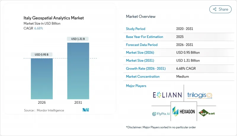
이탈리아의 지리공간 분석 시장은 2025년 8억 9,000만 달러에서 2026년에는 9억 5,000만 달러로 성장하고 2026년부터 2031년에 걸쳐 CAGR 6.68%로 성장을 지속하여 2031년까지 13억 1,000만 달러에 달할 것으로 예측됩니다.

성장의 기반은 EU 자금에 의한 디지털 전환, 제노바 다리 붕괴 이후 인프라 안전 대책 의무화, 2025년 유틸리티법에 근거한 BIM-GIS 통합의 의무화에 있습니다. 밀라노, 토리노, 볼로냐에서 지자체의 디지털 트윈 도입이 지속적인 플랫폼 수요를 만들어 내고, IRIDE 지구관측 컨스텔레이션이 데이터 공급을 충실화 합니다. HERE 테크놀로지스사가 11억 달러 규모의 AWS 제휴를 활용하여 AI 탑재 위치 정보 서비스를 제공함으로써 클라우드 도입이 가속화되고 있습니다. 2025년 1월부터 기후 변화 보험 의무화에 의해 촉진되는 파라메트릭 보험 수요는 고해상도 리스크 분석의 소비를 더욱 확대하고 기업이 부족한 공간 데이터 사이언스 기술을 외부로 위탁함에 따라 벤더도 성장하고 있습니다.
밀라노시는 181제곱킬로미터의 도시 데이터를 통합한 도시 규모의 디지털 트윈을 도입하여 IoT 센서와 지리공간 분석 플랫폼을 연계하고 교통 흐름과 건축물의 에너지 사용을 최적화하고 있습니다. 토리노시는 라바짜 캠퍼스 트윈의 교훈을 전지구 자산 감시로 확대하여 공간 이용 비용을 12% 절감했습니다. 볼로냐의 스마트 모빌리티 상황실에서는 하루 487,700킬로미터의 도로 데이터를 처리하여 피크 시 정체를 9% 줄였습니다. 5세대 모바일 통신 네트워크가 데이터 스트리밍을 뒷받침하고 도시에는 확장 가능한 클라우드 네이티브 지리공간 솔루션이 도입되고 있습니다. 이 프로젝트는 재현 가능한 EU 스마트 시티 프레임워크의 청사진 역할을 하며 이탈리아의 지리공간 분석 시장의 수요를 강화하고 있습니다.
제노바 재해 후, 이탈리아 고속도로공사는 2024년에 1,407회의 드론 비행을 실시하여 SAR 강화 해석에 의해 결함 검출 정밀도를 11% 향상시켰습니다. 국가 가이드라인에서는 현재 60,000개의 교량과 542개의 댐에 대해 위성 간섭 측량에 의한 mm 단위의 변형 추적이 의무화되고 있습니다. 디지털 트윈 기술에 의해 위성 데이터와 지상 센서를 연계시켜 16,800km에 이르는 철도 자산의 예지 보전 대시보드를 제공하고 있습니다. 이에 따라 예산 재분배가 실현되고 분석 벤더에 대한 다년간의 계약이 확보됨과 동시에 이탈리아의 지리공간 분석 시장의 성장을 가속하고 있습니다.
이탈리아 기업의 76%가 공간 분석직의 채용에서 어려움을 보고하고 있으며, 이는 연간 STEM 졸업생이 불과 6,200명인 상황에 기인합니다. 2024년 AI 투자는 전체 IT 예산의 8.2%에 머물렀으며 EU 평균의 13.5%를 밑돌면서 단순 노동력 공급망이 부각되고 있습니다. 대학에서는 클라우드 네이티브 지리공간 아키텍처에 대한 커리큘럼을 반영하기 어렵고, 기업은 서비스 제공업체에 기능을 외주하기 어렵습니다. 그 결과 프로젝트 비용이 늘어나 이탈리아의 지리공간 분석 시장의 침투가 지연되고 있습니다.
2025년 솔루션은 이탈리아의 지리공간 분석 시장에서 56.00%의 점유율을 차지했습니다. 이는 컴플라이언스 및 모니터링을 위해 엔드 투 엔드 플랫폼을 구매자가 선택했기 때문입니다. 그러나 서비스는 12.55%의 연평균 복합 성장률(CAGR)을 기록하여 전문적인 설정 지식을 필요로 하는 BIM-GIS의 의무적인 도입에 힘입어 그 차이를 줄일 것으로 예측되고 있습니다. 심각화하는 기술 부족이 아웃소싱을 촉진하고 컨설팅 기업이 고객을 대신하여 클라우드, AI, 지리공간 기능을 통합하는 움직임이 나타나고 있습니다.
서비스 분야는 이탈리아의 지리공간 분석 시장에서 규모가 확대되고 있으며 이는 매니지드 디지털 트윈 운용, 예지 보전 모델링, 자동 특징 추출에 대한 수요를 반영합니다. 북부 지자체는 플랫폼 구축, 워크플로 자동화, 지속적인 데이터 관리를 포괄하는 다년간의 계약을 체결하고 있습니다. 중소기업은 자본 지출을 피하기 위해 구독형 관리 서비스를 선택하고 2031년까지 두 자리 성장세를 강화할 전망입니다.
2025년 시점에서 표면 분석은 이탈리아의 지리공간 분석 시장 규모에서 45.30%를 차지하였으며, 지적 측량과 유틸리티 자산 관리가 이를 뒷받침하고 있습니다. 3차원 도시 트윈과 몰입형 대시보드가 주류가 됨에 따라 지리 시각화 분석은 13.4%의 연평균 복합 성장률(CAGR)로 가장 빠르게 성장할 전망입니다. 네트워크 분석은 연간 1,440억 톤을 취급하는 화물 운송 회랑을 최적화함으로써 물류 분야에서 꾸준한 보급을 유지하고 있습니다.
이탈리아의 지리공간 분석 시장에서 지리 가시화 분야의 점유율 확대는 범용 디바이스에서 실사화 모델을 스트리밍하는 WebGL 대응 플랫폼에 의해 발생합니다. 밀라노의 스포르체스코 성을 포함한 문화재 관리 기관은 이러한 도구를 활용하여 보존 의무와 도시 개발 압력 간의 조화를 도모합니다. 기업은 3D 인사이트를 활용하여 환경영향 평가 단축과 허가승인의 신속화를 실현하고 있습니다.
The Italy geospatial analytics market is expected to grow from USD 0.89 billion in 2025 to USD 0.95 billion in 2026 and is forecast to reach USD 1.31 billion by 2031 at 6.68% CAGR over 2026-2031.
Growth rests on EU-funded digital transformation, infrastructure safety mandates after the Genoa bridge collapse, and mandatory BIM-GIS convergence under the 2025 Public Works Code. Municipal digital-twin rollouts in Milan, Turin, and Bologna generate sustained platform demand, while the IRIDE earth-observation constellation enriches data supply. Cloud deployment accelerates as HERE Technologies leverages a USD 1.1 billion AWS alliance to deliver AI-powered location services. Parametric insurance needs, catalyzed by compulsory climate coverage from January 2025, further expand high-resolution risk analytics consumption, and services vendors grow as firms outsource scarce spatial data science skills.
Milan deployed a city-scale digital twin that integrates 181 sq km of urban data, combining IoT sensors with geospatial analytics platforms to optimize traffic flow and building energy use. Turin extends lessons from the Lavazza campus twin to district-wide asset monitoring that cuts space-utilization costs by 12%. Bologna's smart-mobility control room processes 487,700 km of road data daily, lowering peak-hour congestion by 9%. Fifth-generation mobile coverage underpins data streaming, pushing cities to procure scalable cloud-native geospatial solutions. These projects serve as blueprints for replicable EU smart-city frameworks that reinforce Italy's geospatial analytics market demand.
After the Genoa disaster, Autostrade per l'Italia ran 1,407 drone sorties in 2024, improving defect detection by 11% through SAR-enhanced analytics. National guidelines now require millimeter-level deformation tracking across 60,000 bridges and 542 dams via satellite interferometry. Digital twins link satellite feeds with ground sensors, supplying predictive maintenance dashboards for rail assets spanning 16,800 km. Resulting budget reallocations secure multiyear contracts for analytics vendors and fuel Italy geospatial analytics market growth.
Seventy-six percent of Italian firms report hiring difficulties for spatial analytics roles as annual STEM graduates tally just 6,200. AI investment sits at 8.2% of overall IT budgets in 2024, lagging the EU average of 13.5%, underscoring under-skilled labor pipelines. Universities struggle to refresh curricula on cloud-native geospatial architectures, prompting enterprises to outsource functions to service providers, which, in turn, inflates project costs and slows Italy's geospatial analytics market penetration.
Other drivers and restraints analyzed in the detailed report include:
For complete list of drivers and restraints, kindly check the Table Of Contents.
Solutions accounted for 56.00% of Italy geospatial analytics market share in 2025 as buyers preferred end-to-end platforms for compliance and monitoring. Services posted a 12.55% CAGR, however, and are projected to narrow the gap, propelled by mandatory BIM-GIS rollouts that require specialized configuration expertise. The escalating skills shortage drives outsourcing, letting consultancies integrate cloud, AI, and geospatial functions on behalf of clients.
Italy geospatial analytics market size gains within services reflect demand for managed digital-twin operations, predictive-maintenance modeling, and automated feature extraction. Northern municipalities award multi-year contracts covering platform setup, workflow automation, and continuous data stewardship. SMEs pick subscription-based managed services to sidestep capital outlays, reinforcing double-digit growth momentum through 2031.
Surface analysis delivered 45.30% of the Italy geospatial analytics market size in 2025, underpinned by cadastral mapping and utility asset management. Geo-visualization analysis grows fastest at 13.4% CAGR as three-dimensional city twins and immersive dashboards hit mainstream adoption. Network analysis retains steady uptake in logistics by optimizing freight corridors that handle 144 billion tonne-kilometers annually.
Italy's geospatial analytics market share gains for geo-visualization stem from WebGL-enabled platforms that stream photorealistic models on commodity devices. Heritage-site custodians, including Milan's Castello Sforzesco, employ these tools to reconcile preservation mandates with urban-development pressures. Enterprises leverage 3D insights to shorten environmental-impact assessments and accelerate permit approvals.
The Italy Geospatial Analytics Market Report is Segmented by Offering (Solution, Service), Type (Surface Analysis, and More), End-User (Transportation and Logistics, Government and Defence, and More), Technology (GIS Software, Remote-Sensing and Earth Observation, and More), Deployment (Cloud, On-Premise), Organisation Size (Large Enterprises, Smes), and Geography. The Market Forecasts are Provided in Terms of Value (USD).