ㅁ Add-on 가능: 고객의 요청에 따라 일정한 범위 내에서 Customization이 가능합니다. 자세한 사항은 문의해 주시기 바랍니다.
ㅁ 보고서에 따라 최신 정보로 업데이트하여 보내드립니다. 배송기일은 문의해 주시기 바랍니다.
한글목차
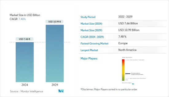
시장 규모는 2024년 76억 6,000만 달러로 추정되며, 2029년에는 109억 9,000만 달러에 달할 것으로 예상되며, 예측 기간(2024-2029년) 동안 7.48%의 CAGR로 성장할 것으로 예상됩니다.
주요 하이라이트
해상 항해는 선박의 항해 계획, 관리 및 지시를 포함하며 선원, 전문 지식 및 과학 기술의 통합에 의존합니다.
해상에서 선박은 안전하고 효율적으로 목적지에 도달하기 위해 위치, 속도, 방향에 대한 정확한 데이터에 의존합니다. 이러한 정확성의 필요성은 출항 및 입항 시 특히 중요합니다. 선장과 항해사 등 해양 전문가들은 해상에서 선박을 안내하기 위해 선박 항법 소프트웨어를 사용합니다. 이 소프트웨어는 위성항법시스템(GNSS), 전자항법도(ENC), 실시간 데이터 및 고급 알고리즘을 통합하고 있습니다. 이러한 기술들이 결합되어 정확한 포지셔닝, 항로 계획, 충돌 방지 등 효과적인 해상 항해에 필수적인 기능을 제공합니다.
해양 내비게이션 소프트웨어는 오늘날 선원들에게 필수적인 요소로 자리 잡으며 해상 안전, 효율성 및 환경적 책임감을 향상시키고 있습니다. 이 소프트웨어를 통해 사용자는 보다 정확한 도착 시간을 계획하고, 보다 안전한 경로를 항해하며, 사고 위험을 줄이고, 효율성을 개선하고, 배기가스 배출을 줄이고, 지속적인 연료 절감을 실현할 수 있습니다.
크루징, 세일링, 레이싱과 같은 해양 레크리에이션의 인기가 급증하고 있습니다. 이러한 활동에는 각각 고유한 요구사항이 있으며, 안전과 사용 편의성이 최우선 순위입니다. 항로 계획, AIS 기능, 레이더 오버레이, 어군 탐지기 등의 기능은 중요하지만 그 중요도는 다양합니다. 그 결과, 경로 계획, 보안 콘, 주행거리계 내비게이션 등 레크리에이션용 해양 내비게이션 소프트웨어에 대한 수요가 증가하는 추세입니다.
오늘날 휴대폰에 내비게이션 앱을 설치하지 않은 선원은 드물며, 요트에서는 고정식 다기능 디스플레이(MFD)보다 태블릿이 선호되고 있습니다. 항해 정보를 손에 쥐고 있는 것은 편리하지만, 선원들은 모터보트를 타는 사람들에 비해 우선순위가 다른 정보를 선호합니다. 기상 정보 업데이트도 좋지만, 조석 예보를 이해하는 것이 가장 중요합니다. 선원들은 바람의 방향, 항로와의 연관성, 주변 랜드마크와 같은 세부 정보를 더 중요하게 여깁니다. 레저용 해양 내비게이션 소프트웨어는 이 모든 서비스를 하나의 플랫폼에 통합하고 있습니다.
레저용 해양 내비게이션 소프트웨어 시장 동향
레저용 해양 내비게이션의 IoT 기술 및 위치정보 근접성 통합으로 시장 성장 촉진
유엔의 국제해사기구(IMO)는 처음에 "e-navigation"이라고 불리는 해상 IoT 개념을 도입했습니다. 이 이니셔티브의 핵심 목표는 해양 항해 데이터를 간소화하고 디지털화하여 광범위한 해양 서비스를 강화하는 것이었습니다. 다른 IoT 애플리케이션과 마찬가지로 강력한 통신, 특히 MTC(Machine Type Communication)는 이 비전을 실현하는 데 매우 중요한 역할을 합니다.
레이더와 오토파일럿이 진화하는 한편, iOS 보트 애플리케이션의 종류도 다양해지고 있습니다. 오늘날 스마트폰에 내비게이션 앱을 설치하지 않은 선원은 거의 찾아보기 힘들다. 실제로 많은 사람들이 요트의 고정식 다기능 디스플레이(MFD)보다 태블릿을 선택하며, 이동 중에도 내비게이션 정보를 바로 확인할 수 있는 이점을 높이 평가하고 있습니다. 다양한 선택지가 있는 가운데, 몇 가지 내비게이션 앱이 선원들 사이에서 인기를 끌고 있습니다.
선원이나 요트 소유자의 우선순위는 모터보트를 타는 사람들과는 다릅니다. 날씨를 파악하는 것이 여전히 중요하지만, 선원들은 조석 패턴, 바람의 강약, 항해에 미치는 영향, 특히 코스와의 연관성을 이해하는 데 중점을 둡니다. 또한, 인근의 흥미로운 명소에 대한 인사이트를 추구하여 레크리에이션 항해 경험을 향상시킵니다.
북미가 가장 큰 시장 점유율을 차지
미국 해안경비대 및 보트 안전 협회의 보고서에 따르면 2023년 미국이 약 1,150만 척의 레저용 보트를 등록하여 전 세계 보트 등록 대수에서 1위를 차지할 것으로 예상했습니다. 캐나다는 레크리에이션 보트 분야에서 중요한 플레이어로 부상할 것입니다.
전통적으로 한 나라의 레저 보트 수는 GDP 및 인구와 상관관계가 있습니다. 경제 규모와 인구가 클수록 보트 수가 많아지는 경향이 있지만 예외도 있습니다. 예를 들어 캐나다를 들 수 있습니다. 미국에 비해 인구가 적음에도 불구하고 캐나다는 전 세계적으로 주목할 만한 레저 보트 수를 자랑합니다. 이 특이성은 주로 광활한 해안선과 복잡한 운하망으로 인해 강력한 보트 문화가 형성되어 있기 때문입니다.
북미 레저용 해양 내비게이션 소프트웨어 시장의 성장을 촉진하는 몇 가지 요인이 있습니다. 가처분 소득 증가, 도시화, 높은 기술 도입률, 야외 활동에 대한 관심 증가 등이 있습니다. 인구가 증가하고 고급 해양 항법 기술을 수용함에 따라 레크리에이션용 해양 항법 소프트웨어에 대한 수요는 더욱 증가할 것으로 예상됩니다.
레저용 해양 내비게이션 소프트웨어 산업 개요
레저용 해양 내비게이션 소프트웨어 시장에서는 Timezero, i-Boating, Rose Point, Expedition Marine 등 주요 업체들이 치열한 경쟁을 벌이고 있습니다. 이들은 인수, 출시, 협업 등의 전략을 활용하여 최첨단 소프트웨어를 출시하고 있습니다. 또한, 이들 기업은 연구개발을 우선순위에 두고 끊임없이 기술의 한계를 뛰어넘어 시장 우위를 확고히 하고 있습니다.
2024년 4월, AI 해양 솔루션 선도기업인 씨드로닉스(Seadronix)는 최신 혁신 기술인 Rec-SEA 플러그인(Rec-SEA Plug-in)을 발표했습니다. 이 첨단 AI 소프트웨어는 LiDAR 및 RADAR와 같은 선상 센서를 활용하여 기존 선박을 '스마트'한 선박으로 전환하여 Rec-SEA 플러그인은 안전성을 향상시킬 뿐만 아니라 해양 환경에서의 업무 효율성을 향상시킵니다.
2024년 3월, Kongsberg Discovery는 관성 항법 제품 라인 30주년을 기념하여 Seapath(R) 385를 출시하였습니다. 최첨단 하드웨어와 첨단 항법 알고리즘을 결합한 이 최신 시스템은 수로 측량에서 타의 추종을 불허하는 정확도를 보장하며, Seapath 385는 관성 기술과 처리 알고리즘을 다주파 GPS, GLONASS, Galileo, Beidou, QZSS, 정지궤도 위성 등 다양한 위성 신호와 통합합니다. Kongsberg Discovery의 프리미엄 MGC(R)(모션 자이로컴퍼스) 또는 MRU(Motion Reference Unit) 관성 센서의 데이터를 GNSS 데이터와 함께 원활하게 처리하여 RTK, PPP 또는 DGNSS 보정을 제공합니다.
기타 혜택:
엑셀 형식의 시장 예측(ME) 시트
3개월간 애널리스트 지원
목차
제1장 소개
조사 성과
조사 가정
조사 범위
제2장 조사 방법
제3장 주요 요약
제4장 시장 역학
시장 개요
시장 성장 촉진요인
IoT 기술과 위치 근접의 통합
GIS, 매핑, 모델링 툴의 진보
클라우드 기반 전개 증가
시장 성장 억제요인
인프라의 높은 초기 비용
오픈 소스 소프트웨어 이용 가능성
업계의 매력 - Porter's Five Forces 분석
신규 참여업체의 위협
구매자/소비자의 협상력
공급 기업의 교섭력
대체품의 위협
경쟁 기업 간의 경쟁 강도
주요 사용 사례와 사례 연구
생태계 분석
제5장 시장 세분화
제품별
소프트웨어
서비스
전개 방식별
클라우드
온프레미스
플랫폼별
랩톱
모바일
지역별
북미
유럽
아시아태평양
세계 기타 지역
제6장 경쟁 상황
기업 개요
Timezero
i-Boating
Rose Point
EuroNav
Expedition Marine
NaAVIC
Chetu
BME-Barrenjoey Marine Electrics
Danelec Marine A/S
Periskal Group
제7장 투자 분석
제8장 시장 기회와 향후 동향
ksm
영문 목차
영문목차
The Market size is estimated at USD 7.66 billion in 2024, and is expected to reach USD 10.99 billion by 2029, growing at a CAGR of 7.48% during the forecast period (2024-2029).
Key Highlights
Marine navigation involves planning, managing, and directing a vessel's voyage, relying on seamanship, professional expertise, and the integration of science and technology.
At sea, vessels depend on precise data regarding their position, speed, and heading to reach their destinations safely and efficiently. This need for accuracy is especially crucial during port departures and arrivals. Maritime professionals, such as ship captains and navigators, utilize marine navigation software to guide vessels at sea. This software integrates Global Navigation Satellite Systems (GNSS), electronic navigation charts (ENCs), real-time data, and advanced algorithms. Together, these technologies provide precise positioning, route planning, collision avoidance, and other essential features for effective maritime navigation.
Marine navigation software has become indispensable for today's sailors, enhancing maritime safety, efficiency, and environmental responsibility. By leveraging this software, users can plan more precise arrival times, sail safer routes, reduce the risk of incidents, improve efficiency, and cut emissions, leading to continual fuel savings.
Marine recreational activities, such as cruising, sailing, and racing, are experiencing a surge in popularity. Each of these activities has its own unique requirements, with safety and user-friendliness being top priorities. Features like route planning, AIS capabilities, radar overlays, and fish finders, while important, hold varying degrees of significance. Consequently, the demand for recreational marine navigation software, including route planning, security cones, and odometer navigation, is on the rise.
Today, it's uncommon to find a sailor without a navigation app on their phone, with tablets increasingly preferred over fixed multifunction displays (MFDs) on yachts. While having navigation information at hand and on the go is convenient, sailors prioritize different information compared to motorboaters. While weather updates are appreciated, understanding the tide forecast is paramount. Sailors focus on details like wind direction, its relevance to their course, and nearby landmarks. Recreational marine navigation software consolidates all these services in one platform.
Integration of IoT Technology and Location Proximity in Recreational Marine Navigation is Fueling the Market's Growth
The International Maritime Organization (IMO) of the United Nations introduced the concept of maritime IoT, initially termed "e-navigation." This initiative's core objective was to streamline and digitize marine navigation data, enhancing a spectrum of maritime services. As with any IoT application, robust communication, particularly MTC (Machine Type Communication), plays a pivotal role in realizing this vision.
While radar and autopilots have seen advancements, a diverse array of iOS boating applications is increasingly aiding boaters. Today, it's a rarity to encounter a sailor without a navigation app on their smartphone. In fact, many are opting for tablets over fixed multifunction displays (MFDs) on yachts, appreciating the advantage of having navigation information readily available on the go. Amidst the plethora of options, several navigation apps have emerged as favorites among sailors.
For sailors and yacht owners, their priorities differ from those of motorboaters. While weather awareness remains crucial, sailors place a premium on comprehending tide patterns, wind dynamics, and their implications on navigation, especially in relation to their course. Additionally, they seek insights on nearby points of interest, enhancing their recreational sailing experiences.
North America to Hold Largest Market Share
In 2023, the US, with around 11.5 million registered recreational boats, dominated the global count, as reported by the US Coastguard and Boating Safety Association. Canada emerges as a significant player in the recreational boating sector.
Traditionally, a nation's recreational boat count correlates with its GDP and population. While larger economies and populations tend to have more boats, there are exceptions. Take Canada, for example. Despite a smaller population compared to the US, it boasts a notable recreational boat count on the world stage. This anomaly is largely due to its extensive coastline and intricate canal network, nurturing a robust boating culture.
Several factors are driving the growth of North America's recreational marine navigation software market. These include rising disposable incomes, urbanization, a strong tech adoption rate, and a growing interest in outdoor activities. As the population swells and embraces advanced marine navigation technology, the demand for recreational marine navigation software is set for further growth.
Recreational Marine Navigation Software Industry Overview
In the Recreational Marine Navigation Software market, key players like Timezero, i-Boating, Rose Point, and Expedition Marine engage in fierce competition. They leverage strategies like acquisitions, launches, and collaborations to roll out cutting-edge software. These firms also prioritize R&D, constantly pushing the boundaries of technology to cement their market dominance.
April 2024: Seadronix, a key player in AI maritime solutions, introduced its latest innovation: the Rec-SEA Plugin. This advanced AI software transforms traditional vessels into 'smart' ships by leveraging onboard sensors such as LiDAR and RADAR. The Rec-SEA Plugin not only enhances safety but also elevates operational efficiency in maritime environments.
March 2024: Celebrating the 30th anniversary of its inertial navigation product line, Kongsberg Discovery unveiled the Seapath(R) 385. This state-of-the-art system combines cutting-edge hardware with advanced navigation algorithms, ensuring unmatched precision for hydrographic surveying. Seapath 385 integrates inertial technology and processing algorithms with a wide array of satellite signals, including multi-frequency GPS, GLONASS, Galileo, Beidou, QZSS, and geostationary. It seamlessly processes data from Kongsberg Discovery's premium MGC(R) (motion gyro compass) or MRU (motion reference unit) inertial sensors, alongside GNSS data, offering RTK, PPP, or DGNSS corrections.
Additional Benefits:
The market estimate (ME) sheet in Excel format
3 months of analyst support
TABLE OF CONTENTS
1 INTRODUCTION
1.1 Study Deliverables
1.2 Study Assumptions
1.3 Scope of the Study
2 RESEARCH METHODOLOGY
3 EXECUTIVE SUMMARY
4 MARKET DYNAMICS
4.1 Market Overview
4.2 Market Drivers
4.2.1 Integration of IoT Technology and Location Proximity
4.2.2 Advancement in GIS, Mapping, and Modelling Tools
4.2.3 Rise in Cloud-based Deployment
4.3 Market Restraints
4.3.1 High Initial Expenses in Infrastructure
4.3.2 Availability of Open-source Software
4.4 Industry Attractiveness - Porter's Five Forces Analysis